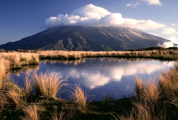
3.1 Four Seasons in New Zealand
Saturday, August 18, 2007
FQ 2. Describe the distribution pattern of farming in New Zealand.
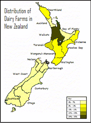
2.1 Where is dairy farming located in NZ?
Different farm types have different resource requirements. Dairy farming needs specific natural resources like
- flat land
- fertile soil
- plenty of sunshine and rain
- close to population centres
Look closely at this map to see dairy farming is mostly located. Look at a relief and climate map of New Zealand to see exactly why dairy farming is located in these areas.
2.2 New Zealand’s farming resources
Cultural Resources
PEOPLE:
The people on the farms are resources. They provide labour, knowledge, skills, and perception. All of these affect the type of farming that happens; how the farm is managed, where the farm is bought, and how efficiently the farm is run. An example of farming knowledge is agricultural research (which happens at Ruakura in Hamilton). Farming skills include fencing, shearing and pasturing.
SERVICES:
Another kind of resource is services (these are services to the farmer). These include financial (eg. Rural banks and banking), government (eg. Ministry of Agriculture and Fisheries (MAF) officers and advisors), professional (eg universities), and agricultural (eg. Marketing boards). These provide advice and direction, money, efficiency, informal management and marketing.
FACILITIES:
Facilities include buildings (sheds), technology, machinery and transport for storage and general equipment. New technologies can enable farmers to do certain tasks much faster, allowing them to spend time doing other things.
Natural Resources
LAND:
The kind of land available, affects the kind of farming that happens on the land. For example, a lot of horticulture and dairy farming is found on lowland plains, while gentle rolling hills are used for sheep and beef farming. Most of New Zealand is a mixture of hills and mountains, with plains and plateaus sparsely placed in between. Most farming is carried out on the plains (close to sea level) or on low land plateaus.
SOIL:
Farming needs certain kinds of soils. A deep soil, rich in minerals is best for farming. Soils in New Zealand range from alluvial (to do with rivers) to volcanic and are the result of different natural processes. Many lowland areas have alluvial soils that are good for horticulture. Most of New Zealand is hilly with thin soils which are suitable mainly for tree or grass growth.
SUN:
The sun is responsible for temperature and sunshine hours. New Zealand’s location (between 35˚S and 47˚S) means that overall the country has mild temperatures and high sunshine hours. New Zealand’s temperature (which affects how long and how much you can grow) is excellent for growing in spring and summer and average in winter and autumn. Some temperatures in the north allow you to grow crops all year long. Sunshine hours are important for the ripening of fruit and vegetables (photosynthesis) and growing of grass. Most of New Zealand gets between 1800 and 2200 hours of sunshine per year.
RAIN:
Precipitation (rain, hail, sleet and snow). Plants and animals need water to survive. Much of New Zealand receives at least 1000mm per annum (per year). Fiordland is very wet (well over 3000mm); while Otago can be quite dry (can receive less than 500mm). Water keeps moving between the sky and the earth in the hydrological cycle.
FQ 1. Describe perceptions of resources: renewable, non-renewable, sustainable management.
1.1 Thoughts on resources
Accessibility is very important – remote locations make resources costly to develop.
Eg. The further away a farm is located from towns the more expensive it is to run. Vets will charge more, labourers will charge more…..
Some resources which were once valuable have now lost their importance.
Eg. A stool and a milk pale (bucket) are no longer resources that farmers value hugely.
Resources can go in and out of fashion.
Eg. Fertiliser was considered a “good thing” until people wanted to make sure that they were eating organic food.
Resources can have more than one use.
Eg.
Milk is made into a huge variety of milk types (low fat, calci trim); however milk is used to make cheese, sour cream, cream, butter…
Resources will only last as long as people choose to let them last.
Eg. If farmers over fertilise their land they run the risk of grass not growing as the soil becomes contaminated.
Use of resources can sometimes cause conflict.
Eg. People living near farms complain about tractors and cows mooing in the early hours of the morning. Noise restrictions could be imposed restricting the hours that farmers can work.
The use of some resources has created environmental problems.
Eg. Farmers have created pollution in local waterways as cow waste is allowed to enter the waterways without treatment.
The Resource Management Act (RMA), 1991 aims to make resource use sustainable.
Eg. Before farmers can build new facilities on their farms, they must gain resource consent and comply with all the laws so that the environment is not destroyed in any way.
1.2 Resources?
- A resource is something we use.
- A natural resource is a resource made by nature (not people).
- A cultural resource is a resource made by people (not nature).
Eg Natural Resources
- Indigenous Trees
- Rivers
- Sea
- Mountain
- Fish
- Sun
- Air
- Rain (precipitation)
- Grass
- Soil (eg volcanic soils)
eg. Cultural resources
- People
- Bread
- Genetically modified food
- Pens, books, pencils, chairs, tables
- Cars, tractor, quad bike, train, bus, bike
- Machines
- Milk shed
- Barn
- House
- Roads
- Concrete, metal
- Fences and gates
- Cows!!!!! Because the farmer breeds them.
Natural resources can be further classified as:
Renewable resources are resources which, after being used, can naturally replace or restore themselves. Eg water, air, soil, vegetation, sunshine.
Non-renewable resources are resources which, after being used, will not naturally replace or restore themselves, eg. Coal, gold. Once a gold deposit has been mined, it has gone forever.
Renewable resources may not naturally replace, or restore or replenish themselves if their use is not properly managed. Most renewable resources need sustainable management to guarantee their future availability. For example, the natural fertility of soil may not be sustained if the same crop is grown on it year after year. Other renewable resources, such as energy from the sun, are more easily sustained.
New Topic - Resource Use
For the next 2 and a half weeks, we are going to study renewable resource use in the context of dairy farming.
Case Study: Mr Wootton's Dairy Farm in Pukekawa
Acheivement Standard 90204 - 3 External Credits.
Focusing Questions
1. Describe perceptions of resources: renewable, non-renewable, sustainable management.
2. Describe the distribution pattern of farming in New Zealand.
3. Describe the annual cycle of a dairy farm (winter, autumn, summer, spring).
4. Describe the system of dairy farming (inputs, processes, outputs, feedbacks).
5. Describe how different people perceive the environmental impacts of dairy farming and the measures taken to resolve these impacts (natural and cultural, renewable and non-renewable, resource sustainability).
Saturday, August 11, 2007
FQ 6. How can people increase or decrease the likelihood or the effects of volcanic eruptions?
6.1 How can people increase the likelihood of a volcanic eruption?
A volcanic eruption is a natural event – therefore people are not able to increase the likelihood of an eruption occurring. However, people are able to influence the effect a volcanic eruption will have on them.
6.2 How can people increase the effects of a volcanic eruption?
1. Migration of people to volcanic hazard sites:
As the population grows there is more pressure to use available land. The sides of many volcanic cones are therefore under pressure to be built on. For example, Mt Eden in Auckland.
2. Population growth = more buildings:
As the numbers of people increases, so does the number of buildings and facilities which are increasingly expensive to replace. For example, a volcanic eruption would cause much more devastation today than it would have 100 years ago.
3. More people using ski fields:
As our disposable income increases, people today are more likely to visit ski fields in potentially hazardous locations. For example the number of tourists to Whakapapa has more than doubled in the last 20 years.
4. Farmland is used more intensively:
The good volcanic soils in volcanic areas are put to good use today with intensive farming methods (more stock/crops in a small space). The New Zealand economy relies heavily on the Taranaki region; so if a volcanic eruption affected this area, the New Zealand and the local economy would suffer.
5. Time:
The longer it is between volcanic eruptions then the less likely people are to be prepared. Volcanic eruptions occur infrequently in New Zealand, and as a result, people’s perception of volcanoes is that they are not a threat.
6.3 How can people decrease the effects of a volcanic eruption?
1. Seismometers:
These have been set up in three locations – at the crater lake, at Mangaku and at Whakapapa village. Any movement detected will be monitored by a computer at the Department of Conservation (DOC) visitor centre, which if significant, will be relayed to the ski fields where alarms will ring.
2. Lahar warning systems:
Vibration sensors can detect any slight movement in the crater lake that will be sent to a computer at Tokaanu. The computer then relays this information to DOC and the police. Flashing lights and signs can then be put into place to divert traffic and stop trains at risk.
3. An automatic water level recorder:
This has been set up in the Whangaehu River to detect sudden change in level that may signal a lahar. Trains can then be prevented from crossing bridges at risk.
4. Tiltmeters:
These are used to measure any significant change in the shapes of Ruapehu that could indicate a volcanic eruption is likely.
5. Lake samples:
These are taken regularly and tested for changes in temperature and chemicals present.
6. Heat-sensitive satellites:
These cameras can detect heat changes that could indicate if magma is rising.
7. Remote control cameras:
These are permanently set up at the crater lake so that pictures of the vent can be relayed at any time to vulcanologists.
8. Civil Defence practice:
Emergency teams are constantly checking that the correct procedures are known and will work.
Think about how people can decrease effects of a volcanic eruption BEFORE, DURING and AFTER. Categorise 6.3 into these three headings.
FQ 5. What are the effects of a volcanic eruption on economic and social activities?
Extreme Natural Events can impact people in a number of ways. Businesses can be closed, infrastructure can be destroyed. Local schools and hospitals may be damaged and people may get injured or even be killed. These impacts can be categorised as impacts on economic activities (things relating to the economy and business) and social activities (things relating to people and families).
ECONOMIC EFFECTS
Negative Effects on Economic Activities
1. Property damage – millions of dollars
EG. The Mt Ruapehu eruption in 1995 cost NZ $130,000,000 in damage to infrastructure, property and tourism.
2. Tourism decreases
EG. After the Mt Ruapehu eruption in 1995 Napier and Gisborne airports closed due to the ash clouds. It was too dangerous for planes to fly around these flight paths. This cost meant that business was lost. On Mt Ruapehu, the Turoa ski field and other fields were closed causing many jobs to be lost. This meant that people were unable to support their families and had to move away from the area. Even after the eruption, millions of dollars were lost in tourism as tourists decided to spend their tourist dollars in ‘safer’ areas.
3. Farm land destroyed by lahars, ash and pumice
4. Pastures, stock and crops are damaged from ash covering
EG. After the Mt Ruapehu eruption in 1995 farmers lost stock after they drank ash contaminated water; and in Gisborne 2000 ewes and lambs died from eating ash covered grass.
5. Vehicles are damaged from ash particles in the atmosphere
EG. Ash from the Mt Ruapehu eruption in 1995 damaged vehicles driving along the desert road. Radiators were damaged as the ash entered vehicle engines. This impacted the transportation companies as they had to travel on different routes to avoid the ash. Aeroplanes were also checked rigorously meaning more man hours for airline companies.
6. Flooding of areas make them inaccessible and unusable
Positive Effects on Economic Activities
1. Soil becomes suitable for forestry
EG. Volcanic Plateau
2. Geothermal steam is used to generate electricity
EG. Wairakei
3. New tourist attractions are created
EG. Mt Tarawera
4. A chance to build the economy and infrastructure
5. The creation of employment to rebuild area
6. Ash makes soil more fertile for farming
EG. Taranaki region, but not around Mt Ruapehu
7. Pumice added to soil can increase drainage
8. Volcanic rock is formed which can be quarried and used in road construction
9. Volcanic Cones in high altitude areas with snowfalls can be used as ski fields.
SOCIAL ACTIVITIES
Negative effects on Social Activities
1. Injuries and a loss of lives
EG. Fortunately during the Mt Ruapehu eruption of 1995, no lives were lost. This was due to excellent warning systems from Civil Defence and people having enough time to prepare and evacuate hazardous areas.
2. People are emotionally and physically stressed by the disaster and the loss it has caused
3. People’s homes and property are damaged or destroyed.
EG. Roofs of houses were covered in ash which caused erosion in towns like Ohakune. Local residents’ gardens were burnt by ash.
4. Water supplies can be contaminated
EG. Water supplies around Mt Ruapehu were contaminated. People were instructed to boil water or drink bottled water trucked in from Taupo.
Positive effects on Social Activities
1. The community works together
EG. Maori tribes in the BOP and Coromandel offered tribes affected by the Tarawera eruption, some of their land
2. Families work together and appreciate each other
FQ 4. What are the effects of a volcanic eruption on the natural environment?
4.1 Effects of a volcanic eruption on topography
Topography: shape of the land will change as landforms are destroyed and built…
- The land is built up, as layers of tephra, lava, lahar and pyroclastic flows are deposited
- The topes of volcanic cones can collapse or blow up (depending on eruption kind)
- New craters or caldera can form, some filling with water (Ruapehu crater lakes)
- The flanks of old volcanic cones can erode leaving the hard plug expose
EG. During the Mt Ruapehu eruption in 1995, the shape of the crater lake was changed due to the explosion of the plug. The explosion and lahars also helped to change the topography of the peak of Mt Ruapehu.
4.2 Effects of a volcanic eruption on drainage
Drainage: rivers and lakes change…
- Rivers can be diverted if volcanic material blocks old river courses
- A change in the topography (shape of the land) can change drainage patterns (under ground water drainage)
- Lahars can flow into rivers, raising the water level (Tangiwai Disaster, 1953)
- Waterways may become polluted with ash
EG. During the Mt Ruapehu eruption in 1995, ash contaminated rivers and streams. The Whangaehu River was swollen by the lahars that entered it. The Yellow and Grey lakes on Mt Ruapehu became interconnected after the eruption.
4.3 Effects of a volcanic eruption on vegetation
Vegetation: forests and grass lands will disappear…
- Close to the eruption vegetation can be blown over or burnt as a result of lava and pyroclastic flows
- Vegetation can be covered in ash
EG. During the Mt Ruapehu eruption in 1995, ash covered native forests in the area burning some trees and bushes.
4.4 Effects of a volcanic eruption on soils
Soil: composition changes…
- Areas receiving volcanic ash will often enjoy an increase in soil fertility
- Areas receiving scoria or pumice will develop as well-drained soil
- Too much volcanic material can create a soil deficient in cobalt, making it unsuitable for farming (Volcanic Plateau, Central NI)
EG. During the Mt Ruapehu eruption in 1995, ash covered existing soil. This has contaminated the soil surrounding Mt Ruapehu and limits what can be grown in the area.
4.5 Effects of a volcanic eruption on fauna
Fauna: wildlife may die…
- Wildlife may die if caught in the lava flows and the eruption
- Wildlife may struggle to find food and water after eruption
EG. During the Mt Ruapehu eruption in 1995, fish died in waterways due to ash contaminated streams and rivers.
4.6 Effects of a volcanic eruption on the atmosphere
Atmosphere: ash contaminates the air.
EG. During the Mt Ruapehu eruption in 1995, ash was found 140km away from the eruption.
Each of these effects need diagrams.
See Mrs O'Hagan for notes on the effects of the Mt Tarawera eruption.
FQ 3. What is the sequence of events that occur in a volcanic eruption?
When an extreme natural event occurs, the event will follow a series of events. These events will be NATURAL and CULTURAL.
When talking about the sequence of events we categorise the sequence of events into BEFORE, DURING and AFTER. Sometimes other names are used to desribe the different timing of the whole sequence of events. For example Preparation is often used to describe BEFORE and Recovery & Rehabilatation can describe AFTER.
MAKE SURE when answering an exam question to read the question and only explain and give the information it asks for.
See Mrs O’Hagan for the work sheets for this. They have all the detailed notes for each case study which you can glue into your books.
FQ 2. What are the processes that produce a volcanic eruption?
Mt Tarawera Eruption 1886
Step 1:
Convection currents move magma around under the Pacific and Indo-Australian Plates.
Step 2:
The Pacific Plate subducts under the Indo-Australian Plate.
Step 3:
- Magma rises through weaknesses in the Indo-Australian Plate in the North Island.
- On the 10th June 1886, shortly after midnight, earthquakes are felt in Te Wairoa and Rotorua.
- Around 1.30am there is a violent earthquake followed by the sound of an explosion.
Step 4:
Pressure builds up in the magma chamber when sulphur dioxide and chlorine combine with steam.
Step 5:
- Mt Tarawera’s Wahanga dome exploded.
- At 2am there was a second explosion as the Ruawahia Peak and then finally the Tarawera Peak erupted.
- The contents of the crater lake blew out and the contents of the lake and terraces spread ash and mud over the surrounding landscape. It was estimated that 2 billion cubic yards of ash were scattered over an area of more than 6000 square miles.
Mt Ruapehu Eruption 1995
Step 1:
Convection currents move magma around under the Pacific and Indo-Australian Plates.
Step 2:
The Pacific Plate subducts under the Indo-Australian Plate.
Step 3:
- Magma rises through weaknesses in the Indo-Australian Plate in the North Island.
- On the 10th June 1886, shortly after midnight, earthquakes are felt in Te Wairoa and Rotorua.
- Around 1.30am there is a violent earthquake followed by the sound of an explosion.
Step 4:
Pressure builds up in the magma chamber when sulphur dioxide and chlorine combine with steam.
Step 5:
- Mt Tarawera’s Wahanga dome exploded.
- At 2am there was a second explosion as the Ruawahia Peak and then finally the Tarawera Peak erupted.
- The contents of the crater lake blew out and the contents of the lake and terraces spread ash and mud over the surrounding landscape. It was estimated that 2 billion cubic yards of ash were scattered over an area of more than 6000 square miles.
See Mrs O'Hagan for diagrams.
Step 1:
Convection currents move magma around under the Pacific and Indo-Australian Plates.
Step 2:
The Pacific Plate subducts under the Indo-Australian Plate.
Step 3:
- Magma rises through weaknesses in the Indo-Australian Plate in the North Island.
- On the 10th June 1886, shortly after midnight, earthquakes are felt in Te Wairoa and Rotorua.
- Around 1.30am there is a violent earthquake followed by the sound of an explosion.
Step 4:
Pressure builds up in the magma chamber when sulphur dioxide and chlorine combine with steam.
Step 5:
- Mt Tarawera’s Wahanga dome exploded.
- At 2am there was a second explosion as the Ruawahia Peak and then finally the Tarawera Peak erupted.
- The contents of the crater lake blew out and the contents of the lake and terraces spread ash and mud over the surrounding landscape. It was estimated that 2 billion cubic yards of ash were scattered over an area of more than 6000 square miles.
Mt Ruapehu Eruption 1995
Step 1:
Convection currents move magma around under the Pacific and Indo-Australian Plates.
Step 2:
The Pacific Plate subducts under the Indo-Australian Plate.
Step 3:
- Magma rises through weaknesses in the Indo-Australian Plate in the North Island.
- On the 10th June 1886, shortly after midnight, earthquakes are felt in Te Wairoa and Rotorua.
- Around 1.30am there is a violent earthquake followed by the sound of an explosion.
Step 4:
Pressure builds up in the magma chamber when sulphur dioxide and chlorine combine with steam.
Step 5:
- Mt Tarawera’s Wahanga dome exploded.
- At 2am there was a second explosion as the Ruawahia Peak and then finally the Tarawera Peak erupted.
- The contents of the crater lake blew out and the contents of the lake and terraces spread ash and mud over the surrounding landscape. It was estimated that 2 billion cubic yards of ash were scattered over an area of more than 6000 square miles.
See Mrs O'Hagan for diagrams.
FQ 1. When does a volcanic eruption become a hazard?
1.1 Extreme Natural Events
Natural Events are events that have been created by nature. These could be rain and wind. These kinds of events occur regularly.
Extreme Natural Events are also events that have been created by nature however they are more extreme and occur much less frequently.
Extreme Natural Events are created through a process. This process is a series of related events.
1.2 Extreme Natural Events in New Zealand
- Volcanic Eruptions
- Earthquakes
- Coastal Erosion
- Landslips
- Flooding
- Droughts
1.3 Extreme Natural Events becoming Natural Hazards
The only time we really need to worry about extreme natural events is when they threaten human activities. As soon as ENEs threaten humans and human activities then they become natural hazards.
Eg. A volcanic eruption on an uninhabitated is an ENE whereas a natural hazard is when Mt Ruapehu erupts and threatens tourist operations and local townships.
Extreme Natural Events AS 90202
Well I know that we haven't posted these notes as we have gone, so they are not going to be quite as good as our last ones. But the basic info is here. Ask Mrs O'Hagan for any resources that you need to glue into your book.
This Ahievement Standard is divided into a New Zealand section and an Overseas section (of which you will use the South-West Pacific).
For now, we will just look a New Zealand Exteme Natural Event - Volcanic Erutions.
Case Studies:
This Ahievement Standard is divided into a New Zealand section and an Overseas section (of which you will use the South-West Pacific).
For now, we will just look a New Zealand Exteme Natural Event - Volcanic Erutions.
Case Studies:
- Mt Tarawera Eruption - 1886
- Mr Ruapehu Eruption - 1995
It is vital that you are able to recall and apply specific and detailed information from both of these case studies to have a chance at gaining Merit and Excellence.
Focusing Questions
1. When does a volcanic eruption become a hazard?
2. What are the processes that produce a volcanic eruption?
3. What is the sequence of events that occur in a volcanic eruption?
4. What are the effects of a volcanic eruption on the natural environment?
5. What are the effects of a volcanic eruption on economic and social activities?
6. How can people increase or decrease the likelihood or the effects of volcanic eruptions?
Other excellent sites:
Mt Tarawera - lots of links and pictures
Subscribe to:
Posts (Atom)