Economic Effects
Government Budget affected:
Ami:
- Overall damage $US 30 million by the cyclone
- There is no money in the govt budget to help pay for the damage, there is a long term impact on the country as they are unable to pay for the damage.
Percy:
- the people of tokelau needed half a million dollars(NZ) to help restore their country.
Damage to industry:
Ami:
- sugar industry damaged from the wind - $US 11 million damage; sugar accounts for 18.5% of Fiji’s foreign currency earnings
- 200,000 people were employed, so their jobs are jeopardised (a quarter of the popn)
Percy:
- damage to buildings, a lot of equipment lost
- fishing boats scattered all over the island
- coconut plantations were damaged from the wind
- breadfruit plantations were damaged from salinisation
Infrastructure destroyed:
Ami:
- Repair to roads - $US 4.9 million by flooding and landslides
Percy:
- communication lines cut, roads broken up and power system is down
- sea wall damaged, however places that had a sea wall were less affected – villages that had sea walls believed their villages would have been swept away had the wall not been there.
Social Effects:
Housing Destroyed:
Ami:
- 2,500 houses destroyed by flooding, storm surges and high winds
Percy:
- 7 houses washed away by storm surges
Deaths and Injuries:
Ami:
- 15 people killed by flying debris in high winds and people drowned in floods
Percy:
- no deaths
- 1 person injured by flying debris
Community Infrastructure:
Ami:
- thousands of people were without power and water so they were unable to cook and drink fresh water. This was caused by flooding and high winds took out they power lines
Percy:
- power system was cut which meant that islands were without communication. High winds and storm surges took out the power supplies
Health Issues:
Ami:
- people got sick with typoid, dengue fever and leptospirosis caused by contaminated drinking water supplies
Percy:
- a number of cases of dengue fever and diarrhea caused by contaminated drinking water supplies
Monday, October 15, 2007
Saturday, September 29, 2007
FQ 5. Describe how different people perceive the environmental impacts of dairy farming and the measures taken to resolve these impacts
Problems, Causes, Solutions to environmental impacts caused by dairy farming:
Problem
- Contamination of ground water by nutrients from cow wastes and nitrogen fertilisers
Cause
- Leaching of nutrients (over supply of nutrients seeping) into soil in paddocks
- Increased stock densities eg Taranaki: 1975 – 1.43 cows/ha compared to 1996 – 1.70 cows/ha
Solution
- Reduce fertiliser application
- Reduce stock densities
- - - - - - - - - - - - - - - - - - - - - - - - - - - - -
Problem
- Contamination of streams, rivers and lakes by nutrients from cow wastes and nitrogen fertilisers
Cause
- Surface run-off from paddocks
- Effluent from cowsheds washed into farm streams from cowsheds
- Increased stock densities
Solution
- Reduce fertiliser applications
- Fence off riparian zones (stream banks) and plant shrubs and trees to trap surface run-off
- Better collection, treatment and disposal of cowshed wastes, eg. Two-pond system (Oxidation Ponds)
- Reduce stock densities
- - - - - - - - - - - - - - - - - - - - - - - - - - - - -
Problem
- Pugging
Cause
- Trampling of grass by cows
- Increased stock densities
Solution
- Create races for the cows to walk on around the farm
- Reduce stock densities
Problem
- Contamination of ground water by nutrients from cow wastes and nitrogen fertilisers
Cause
- Leaching of nutrients (over supply of nutrients seeping) into soil in paddocks
- Increased stock densities eg Taranaki: 1975 – 1.43 cows/ha compared to 1996 – 1.70 cows/ha
Solution
- Reduce fertiliser application
- Reduce stock densities
- - - - - - - - - - - - - - - - - - - - - - - - - - - - -
Problem
- Contamination of streams, rivers and lakes by nutrients from cow wastes and nitrogen fertilisers
Cause
- Surface run-off from paddocks
- Effluent from cowsheds washed into farm streams from cowsheds
- Increased stock densities
Solution
- Reduce fertiliser applications
- Fence off riparian zones (stream banks) and plant shrubs and trees to trap surface run-off
- Better collection, treatment and disposal of cowshed wastes, eg. Two-pond system (Oxidation Ponds)
- Reduce stock densities
- - - - - - - - - - - - - - - - - - - - - - - - - - - - -
Problem
- Pugging
Cause
- Trampling of grass by cows
- Increased stock densities
Solution
- Create races for the cows to walk on around the farm
- Reduce stock densities
FQ 4. Describe the system of dairy farming
A system includes inputs, processes, outputs and feedbacks.
This is a generic system diagram for dairy farming. You need to use specific information from your farm to get Merit and Excellence.
Inputs
- sunshine
- fertile volcanic soils
- rolling relief
- tractors
- cows
- grass
- fertiliser
- herringbone milking shed
Processes
Outputs
- waste
- unused effluent, plastics, spray cans
- silage
- hay
- calves
- profit
Feedbacks
This is a generic system diagram for dairy farming. You need to use specific information from your farm to get Merit and Excellence.
Inputs
- Natural
- sunshine
- fertile volcanic soils
- rolling relief
- Cultural
- tractors
- cows
- grass
- fertiliser
- herringbone milking shed
Processes
- These are all the activities that occur in the annual farming cycle
Outputs
- Negative
- waste
- unused effluent, plastics, spray cans
- Positive
- silage
- hay
- calves
- profit
Feedbacks
- Profits reinvested
- Effluent used as fertiliser
- Heifers used as replacement cows
- Silage and hay used as suppliement feed
3.2 Annual Cycle of Dairy Farming Activities
Activities on a farm are dependant on the season. Different seasons produce different climatic conditions that are condusive (good) for different activities.
Farming activities vary depending on where a farm is located in New Zealand. Remember it is warmer is the North Island than the South Island so farmers would tend to do things later in the South Island compared to the North Island.
Here is a link to a farm in the South Island and the activities they do in each season: Codstream Downs Dairy Farm
The activites down on the Coldstream farm are slightly different to Mr Wootton's farm. Here is the annual cycle on Mr Wooton's dairy farm.
Winter:
- Feeding out/supplementing feed - this is when Mr Wootton feeds hay and silage to the cows because there is very little grass growth for the cows to eat fresh grass.
- Towards the end of winter, Mr Wooton is into calving. The calves are kept in a calf shed until they are weaned off milk and able to eat grass. He wants the calves ready to be able to eat the spring grass. Once calving begins, Mr Wooton can begin milking.
- Once the cows have calved, artifical insemination begins.
Spring:
- Weaning contines
- Milking continues
- Silage is made. This is because there is an oversupply of grass
- Mating (in case the AI has not worked)
- Pregnancy testing
Summer:
- Milking continues
- Hay is made.
- Suppliment is sometimes fed in drought conditions
Autumn:
- Milking reduces to once a day
- Cows are eventually dried off to give them a break
- Maintenance is carried out on the farm
- Cows are drenched
And then winter starts all over again.
These are some of the activities that occur on the annual dairy farming cycle. These are also most of the processes that occur on a dairy farm.
Saturday, August 18, 2007
FQ 3. Describe the annual cycle of a dairy farm (winter, autumn, summer, spring).
3.1 Four Seasons in New Zealand
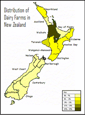
FQ 2. Describe the distribution pattern of farming in New Zealand.
2.1 Where is dairy farming located in NZ?
Different farm types have different resource requirements. Dairy farming needs specific natural resources like
- flat land
- fertile soil
- plenty of sunshine and rain
- close to population centres
Look closely at this map to see dairy farming is mostly located. Look at a relief and climate map of New Zealand to see exactly why dairy farming is located in these areas.
2.2 New Zealand’s farming resources
Cultural Resources
PEOPLE:
The people on the farms are resources. They provide labour, knowledge, skills, and perception. All of these affect the type of farming that happens; how the farm is managed, where the farm is bought, and how efficiently the farm is run. An example of farming knowledge is agricultural research (which happens at Ruakura in Hamilton). Farming skills include fencing, shearing and pasturing.
SERVICES:
Another kind of resource is services (these are services to the farmer). These include financial (eg. Rural banks and banking), government (eg. Ministry of Agriculture and Fisheries (MAF) officers and advisors), professional (eg universities), and agricultural (eg. Marketing boards). These provide advice and direction, money, efficiency, informal management and marketing.
FACILITIES:
Facilities include buildings (sheds), technology, machinery and transport for storage and general equipment. New technologies can enable farmers to do certain tasks much faster, allowing them to spend time doing other things.
Natural Resources
LAND:
The kind of land available, affects the kind of farming that happens on the land. For example, a lot of horticulture and dairy farming is found on lowland plains, while gentle rolling hills are used for sheep and beef farming. Most of New Zealand is a mixture of hills and mountains, with plains and plateaus sparsely placed in between. Most farming is carried out on the plains (close to sea level) or on low land plateaus.
SOIL:
Farming needs certain kinds of soils. A deep soil, rich in minerals is best for farming. Soils in New Zealand range from alluvial (to do with rivers) to volcanic and are the result of different natural processes. Many lowland areas have alluvial soils that are good for horticulture. Most of New Zealand is hilly with thin soils which are suitable mainly for tree or grass growth.
SUN:
The sun is responsible for temperature and sunshine hours. New Zealand’s location (between 35˚S and 47˚S) means that overall the country has mild temperatures and high sunshine hours. New Zealand’s temperature (which affects how long and how much you can grow) is excellent for growing in spring and summer and average in winter and autumn. Some temperatures in the north allow you to grow crops all year long. Sunshine hours are important for the ripening of fruit and vegetables (photosynthesis) and growing of grass. Most of New Zealand gets between 1800 and 2200 hours of sunshine per year.
RAIN:
Precipitation (rain, hail, sleet and snow). Plants and animals need water to survive. Much of New Zealand receives at least 1000mm per annum (per year). Fiordland is very wet (well over 3000mm); while Otago can be quite dry (can receive less than 500mm). Water keeps moving between the sky and the earth in the hydrological cycle.
FQ 1. Describe perceptions of resources: renewable, non-renewable, sustainable management.
1.1 Thoughts on resources
Accessibility is very important – remote locations make resources costly to develop.
Eg. The further away a farm is located from towns the more expensive it is to run. Vets will charge more, labourers will charge more…..
Some resources which were once valuable have now lost their importance.
Eg. A stool and a milk pale (bucket) are no longer resources that farmers value hugely.
Resources can go in and out of fashion.
Eg. Fertiliser was considered a “good thing” until people wanted to make sure that they were eating organic food.
Resources can have more than one use.
Eg.
Milk is made into a huge variety of milk types (low fat, calci trim); however milk is used to make cheese, sour cream, cream, butter…
Resources will only last as long as people choose to let them last.
Eg. If farmers over fertilise their land they run the risk of grass not growing as the soil becomes contaminated.
Use of resources can sometimes cause conflict.
Eg. People living near farms complain about tractors and cows mooing in the early hours of the morning. Noise restrictions could be imposed restricting the hours that farmers can work.
The use of some resources has created environmental problems.
Eg. Farmers have created pollution in local waterways as cow waste is allowed to enter the waterways without treatment.
The Resource Management Act (RMA), 1991 aims to make resource use sustainable.
Eg. Before farmers can build new facilities on their farms, they must gain resource consent and comply with all the laws so that the environment is not destroyed in any way.
1.2 Resources?
- A resource is something we use.
- A natural resource is a resource made by nature (not people).
- A cultural resource is a resource made by people (not nature).
Eg Natural Resources
- Indigenous Trees
- Rivers
- Sea
- Mountain
- Fish
- Sun
- Air
- Rain (precipitation)
- Grass
- Soil (eg volcanic soils)
eg. Cultural resources
- People
- Bread
- Genetically modified food
- Pens, books, pencils, chairs, tables
- Cars, tractor, quad bike, train, bus, bike
- Machines
- Milk shed
- Barn
- House
- Roads
- Concrete, metal
- Fences and gates
- Cows!!!!! Because the farmer breeds them.
Natural resources can be further classified as:
Renewable resources are resources which, after being used, can naturally replace or restore themselves. Eg water, air, soil, vegetation, sunshine.
Non-renewable resources are resources which, after being used, will not naturally replace or restore themselves, eg. Coal, gold. Once a gold deposit has been mined, it has gone forever.
Renewable resources may not naturally replace, or restore or replenish themselves if their use is not properly managed. Most renewable resources need sustainable management to guarantee their future availability. For example, the natural fertility of soil may not be sustained if the same crop is grown on it year after year. Other renewable resources, such as energy from the sun, are more easily sustained.
New Topic - Resource Use
For the next 2 and a half weeks, we are going to study renewable resource use in the context of dairy farming.
Case Study: Mr Wootton's Dairy Farm in Pukekawa
Acheivement Standard 90204 - 3 External Credits.
Focusing Questions
1. Describe perceptions of resources: renewable, non-renewable, sustainable management.
2. Describe the distribution pattern of farming in New Zealand.
3. Describe the annual cycle of a dairy farm (winter, autumn, summer, spring).
4. Describe the system of dairy farming (inputs, processes, outputs, feedbacks).
5. Describe how different people perceive the environmental impacts of dairy farming and the measures taken to resolve these impacts (natural and cultural, renewable and non-renewable, resource sustainability).
Saturday, August 11, 2007
FQ 6. How can people increase or decrease the likelihood or the effects of volcanic eruptions?
6.1 How can people increase the likelihood of a volcanic eruption?
A volcanic eruption is a natural event – therefore people are not able to increase the likelihood of an eruption occurring. However, people are able to influence the effect a volcanic eruption will have on them.
6.2 How can people increase the effects of a volcanic eruption?
1. Migration of people to volcanic hazard sites:
As the population grows there is more pressure to use available land. The sides of many volcanic cones are therefore under pressure to be built on. For example, Mt Eden in Auckland.
2. Population growth = more buildings:
As the numbers of people increases, so does the number of buildings and facilities which are increasingly expensive to replace. For example, a volcanic eruption would cause much more devastation today than it would have 100 years ago.
3. More people using ski fields:
As our disposable income increases, people today are more likely to visit ski fields in potentially hazardous locations. For example the number of tourists to Whakapapa has more than doubled in the last 20 years.
4. Farmland is used more intensively:
The good volcanic soils in volcanic areas are put to good use today with intensive farming methods (more stock/crops in a small space). The New Zealand economy relies heavily on the Taranaki region; so if a volcanic eruption affected this area, the New Zealand and the local economy would suffer.
5. Time:
The longer it is between volcanic eruptions then the less likely people are to be prepared. Volcanic eruptions occur infrequently in New Zealand, and as a result, people’s perception of volcanoes is that they are not a threat.
6.3 How can people decrease the effects of a volcanic eruption?
1. Seismometers:
These have been set up in three locations – at the crater lake, at Mangaku and at Whakapapa village. Any movement detected will be monitored by a computer at the Department of Conservation (DOC) visitor centre, which if significant, will be relayed to the ski fields where alarms will ring.
2. Lahar warning systems:
Vibration sensors can detect any slight movement in the crater lake that will be sent to a computer at Tokaanu. The computer then relays this information to DOC and the police. Flashing lights and signs can then be put into place to divert traffic and stop trains at risk.
3. An automatic water level recorder:
This has been set up in the Whangaehu River to detect sudden change in level that may signal a lahar. Trains can then be prevented from crossing bridges at risk.
4. Tiltmeters:
These are used to measure any significant change in the shapes of Ruapehu that could indicate a volcanic eruption is likely.
5. Lake samples:
These are taken regularly and tested for changes in temperature and chemicals present.
6. Heat-sensitive satellites:
These cameras can detect heat changes that could indicate if magma is rising.
7. Remote control cameras:
These are permanently set up at the crater lake so that pictures of the vent can be relayed at any time to vulcanologists.
8. Civil Defence practice:
Emergency teams are constantly checking that the correct procedures are known and will work.
Think about how people can decrease effects of a volcanic eruption BEFORE, DURING and AFTER. Categorise 6.3 into these three headings.
FQ 5. What are the effects of a volcanic eruption on economic and social activities?
Extreme Natural Events can impact people in a number of ways. Businesses can be closed, infrastructure can be destroyed. Local schools and hospitals may be damaged and people may get injured or even be killed. These impacts can be categorised as impacts on economic activities (things relating to the economy and business) and social activities (things relating to people and families).
ECONOMIC EFFECTS
Negative Effects on Economic Activities
1. Property damage – millions of dollars
EG. The Mt Ruapehu eruption in 1995 cost NZ $130,000,000 in damage to infrastructure, property and tourism.
2. Tourism decreases
EG. After the Mt Ruapehu eruption in 1995 Napier and Gisborne airports closed due to the ash clouds. It was too dangerous for planes to fly around these flight paths. This cost meant that business was lost. On Mt Ruapehu, the Turoa ski field and other fields were closed causing many jobs to be lost. This meant that people were unable to support their families and had to move away from the area. Even after the eruption, millions of dollars were lost in tourism as tourists decided to spend their tourist dollars in ‘safer’ areas.
3. Farm land destroyed by lahars, ash and pumice
4. Pastures, stock and crops are damaged from ash covering
EG. After the Mt Ruapehu eruption in 1995 farmers lost stock after they drank ash contaminated water; and in Gisborne 2000 ewes and lambs died from eating ash covered grass.
5. Vehicles are damaged from ash particles in the atmosphere
EG. Ash from the Mt Ruapehu eruption in 1995 damaged vehicles driving along the desert road. Radiators were damaged as the ash entered vehicle engines. This impacted the transportation companies as they had to travel on different routes to avoid the ash. Aeroplanes were also checked rigorously meaning more man hours for airline companies.
6. Flooding of areas make them inaccessible and unusable
Positive Effects on Economic Activities
1. Soil becomes suitable for forestry
EG. Volcanic Plateau
2. Geothermal steam is used to generate electricity
EG. Wairakei
3. New tourist attractions are created
EG. Mt Tarawera
4. A chance to build the economy and infrastructure
5. The creation of employment to rebuild area
6. Ash makes soil more fertile for farming
EG. Taranaki region, but not around Mt Ruapehu
7. Pumice added to soil can increase drainage
8. Volcanic rock is formed which can be quarried and used in road construction
9. Volcanic Cones in high altitude areas with snowfalls can be used as ski fields.
SOCIAL ACTIVITIES
Negative effects on Social Activities
1. Injuries and a loss of lives
EG. Fortunately during the Mt Ruapehu eruption of 1995, no lives were lost. This was due to excellent warning systems from Civil Defence and people having enough time to prepare and evacuate hazardous areas.
2. People are emotionally and physically stressed by the disaster and the loss it has caused
3. People’s homes and property are damaged or destroyed.
EG. Roofs of houses were covered in ash which caused erosion in towns like Ohakune. Local residents’ gardens were burnt by ash.
4. Water supplies can be contaminated
EG. Water supplies around Mt Ruapehu were contaminated. People were instructed to boil water or drink bottled water trucked in from Taupo.
Positive effects on Social Activities
1. The community works together
EG. Maori tribes in the BOP and Coromandel offered tribes affected by the Tarawera eruption, some of their land
2. Families work together and appreciate each other
FQ 4. What are the effects of a volcanic eruption on the natural environment?
4.1 Effects of a volcanic eruption on topography
Topography: shape of the land will change as landforms are destroyed and built…
- The land is built up, as layers of tephra, lava, lahar and pyroclastic flows are deposited
- The topes of volcanic cones can collapse or blow up (depending on eruption kind)
- New craters or caldera can form, some filling with water (Ruapehu crater lakes)
- The flanks of old volcanic cones can erode leaving the hard plug expose
EG. During the Mt Ruapehu eruption in 1995, the shape of the crater lake was changed due to the explosion of the plug. The explosion and lahars also helped to change the topography of the peak of Mt Ruapehu.
4.2 Effects of a volcanic eruption on drainage
Drainage: rivers and lakes change…
- Rivers can be diverted if volcanic material blocks old river courses
- A change in the topography (shape of the land) can change drainage patterns (under ground water drainage)
- Lahars can flow into rivers, raising the water level (Tangiwai Disaster, 1953)
- Waterways may become polluted with ash
EG. During the Mt Ruapehu eruption in 1995, ash contaminated rivers and streams. The Whangaehu River was swollen by the lahars that entered it. The Yellow and Grey lakes on Mt Ruapehu became interconnected after the eruption.
4.3 Effects of a volcanic eruption on vegetation
Vegetation: forests and grass lands will disappear…
- Close to the eruption vegetation can be blown over or burnt as a result of lava and pyroclastic flows
- Vegetation can be covered in ash
EG. During the Mt Ruapehu eruption in 1995, ash covered native forests in the area burning some trees and bushes.
4.4 Effects of a volcanic eruption on soils
Soil: composition changes…
- Areas receiving volcanic ash will often enjoy an increase in soil fertility
- Areas receiving scoria or pumice will develop as well-drained soil
- Too much volcanic material can create a soil deficient in cobalt, making it unsuitable for farming (Volcanic Plateau, Central NI)
EG. During the Mt Ruapehu eruption in 1995, ash covered existing soil. This has contaminated the soil surrounding Mt Ruapehu and limits what can be grown in the area.
4.5 Effects of a volcanic eruption on fauna
Fauna: wildlife may die…
- Wildlife may die if caught in the lava flows and the eruption
- Wildlife may struggle to find food and water after eruption
EG. During the Mt Ruapehu eruption in 1995, fish died in waterways due to ash contaminated streams and rivers.
4.6 Effects of a volcanic eruption on the atmosphere
Atmosphere: ash contaminates the air.
EG. During the Mt Ruapehu eruption in 1995, ash was found 140km away from the eruption.
Each of these effects need diagrams.
See Mrs O'Hagan for notes on the effects of the Mt Tarawera eruption.
FQ 3. What is the sequence of events that occur in a volcanic eruption?
When an extreme natural event occurs, the event will follow a series of events. These events will be NATURAL and CULTURAL.
When talking about the sequence of events we categorise the sequence of events into BEFORE, DURING and AFTER. Sometimes other names are used to desribe the different timing of the whole sequence of events. For example Preparation is often used to describe BEFORE and Recovery & Rehabilatation can describe AFTER.
MAKE SURE when answering an exam question to read the question and only explain and give the information it asks for.
See Mrs O’Hagan for the work sheets for this. They have all the detailed notes for each case study which you can glue into your books.
FQ 2. What are the processes that produce a volcanic eruption?
Mt Tarawera Eruption 1886
Step 1:
Convection currents move magma around under the Pacific and Indo-Australian Plates.
Step 2:
The Pacific Plate subducts under the Indo-Australian Plate.
Step 3:
- Magma rises through weaknesses in the Indo-Australian Plate in the North Island.
- On the 10th June 1886, shortly after midnight, earthquakes are felt in Te Wairoa and Rotorua.
- Around 1.30am there is a violent earthquake followed by the sound of an explosion.
Step 4:
Pressure builds up in the magma chamber when sulphur dioxide and chlorine combine with steam.
Step 5:
- Mt Tarawera’s Wahanga dome exploded.
- At 2am there was a second explosion as the Ruawahia Peak and then finally the Tarawera Peak erupted.
- The contents of the crater lake blew out and the contents of the lake and terraces spread ash and mud over the surrounding landscape. It was estimated that 2 billion cubic yards of ash were scattered over an area of more than 6000 square miles.
Mt Ruapehu Eruption 1995
Step 1:
Convection currents move magma around under the Pacific and Indo-Australian Plates.
Step 2:
The Pacific Plate subducts under the Indo-Australian Plate.
Step 3:
- Magma rises through weaknesses in the Indo-Australian Plate in the North Island.
- On the 10th June 1886, shortly after midnight, earthquakes are felt in Te Wairoa and Rotorua.
- Around 1.30am there is a violent earthquake followed by the sound of an explosion.
Step 4:
Pressure builds up in the magma chamber when sulphur dioxide and chlorine combine with steam.
Step 5:
- Mt Tarawera’s Wahanga dome exploded.
- At 2am there was a second explosion as the Ruawahia Peak and then finally the Tarawera Peak erupted.
- The contents of the crater lake blew out and the contents of the lake and terraces spread ash and mud over the surrounding landscape. It was estimated that 2 billion cubic yards of ash were scattered over an area of more than 6000 square miles.
See Mrs O'Hagan for diagrams.
Step 1:
Convection currents move magma around under the Pacific and Indo-Australian Plates.
Step 2:
The Pacific Plate subducts under the Indo-Australian Plate.
Step 3:
- Magma rises through weaknesses in the Indo-Australian Plate in the North Island.
- On the 10th June 1886, shortly after midnight, earthquakes are felt in Te Wairoa and Rotorua.
- Around 1.30am there is a violent earthquake followed by the sound of an explosion.
Step 4:
Pressure builds up in the magma chamber when sulphur dioxide and chlorine combine with steam.
Step 5:
- Mt Tarawera’s Wahanga dome exploded.
- At 2am there was a second explosion as the Ruawahia Peak and then finally the Tarawera Peak erupted.
- The contents of the crater lake blew out and the contents of the lake and terraces spread ash and mud over the surrounding landscape. It was estimated that 2 billion cubic yards of ash were scattered over an area of more than 6000 square miles.
Mt Ruapehu Eruption 1995
Step 1:
Convection currents move magma around under the Pacific and Indo-Australian Plates.
Step 2:
The Pacific Plate subducts under the Indo-Australian Plate.
Step 3:
- Magma rises through weaknesses in the Indo-Australian Plate in the North Island.
- On the 10th June 1886, shortly after midnight, earthquakes are felt in Te Wairoa and Rotorua.
- Around 1.30am there is a violent earthquake followed by the sound of an explosion.
Step 4:
Pressure builds up in the magma chamber when sulphur dioxide and chlorine combine with steam.
Step 5:
- Mt Tarawera’s Wahanga dome exploded.
- At 2am there was a second explosion as the Ruawahia Peak and then finally the Tarawera Peak erupted.
- The contents of the crater lake blew out and the contents of the lake and terraces spread ash and mud over the surrounding landscape. It was estimated that 2 billion cubic yards of ash were scattered over an area of more than 6000 square miles.
See Mrs O'Hagan for diagrams.
FQ 1. When does a volcanic eruption become a hazard?
1.1 Extreme Natural Events
Natural Events are events that have been created by nature. These could be rain and wind. These kinds of events occur regularly.
Extreme Natural Events are also events that have been created by nature however they are more extreme and occur much less frequently.
Extreme Natural Events are created through a process. This process is a series of related events.
1.2 Extreme Natural Events in New Zealand
- Volcanic Eruptions
- Earthquakes
- Coastal Erosion
- Landslips
- Flooding
- Droughts
1.3 Extreme Natural Events becoming Natural Hazards
The only time we really need to worry about extreme natural events is when they threaten human activities. As soon as ENEs threaten humans and human activities then they become natural hazards.
Eg. A volcanic eruption on an uninhabitated is an ENE whereas a natural hazard is when Mt Ruapehu erupts and threatens tourist operations and local townships.
Extreme Natural Events AS 90202
Well I know that we haven't posted these notes as we have gone, so they are not going to be quite as good as our last ones. But the basic info is here. Ask Mrs O'Hagan for any resources that you need to glue into your book.
This Ahievement Standard is divided into a New Zealand section and an Overseas section (of which you will use the South-West Pacific).
For now, we will just look a New Zealand Exteme Natural Event - Volcanic Erutions.
Case Studies:
This Ahievement Standard is divided into a New Zealand section and an Overseas section (of which you will use the South-West Pacific).
For now, we will just look a New Zealand Exteme Natural Event - Volcanic Erutions.
Case Studies:
- Mt Tarawera Eruption - 1886
- Mr Ruapehu Eruption - 1995
It is vital that you are able to recall and apply specific and detailed information from both of these case studies to have a chance at gaining Merit and Excellence.
Focusing Questions
1. When does a volcanic eruption become a hazard?
2. What are the processes that produce a volcanic eruption?
3. What is the sequence of events that occur in a volcanic eruption?
4. What are the effects of a volcanic eruption on the natural environment?
5. What are the effects of a volcanic eruption on economic and social activities?
6. How can people increase or decrease the likelihood or the effects of volcanic eruptions?
Other excellent sites:
Mt Tarawera - lots of links and pictures
Wednesday, June 6, 2007
5.4 Solving the problems of a Youthful Populations in Monsoon Asia
Countries in Monsoon Asia have used a variety of different methods to try and reduce birth rates in an effort to reduce the pressure that youthful populations puts on their resources.
The following diagrams show the efforts, successes and consequences of various different methods.
CHINA:
 Consequences of China's Solutions:
China's "one-child" policy increased female infanticide as male children were culturally more desirable. Allowed to have only one child, some parents killed baby girls and tried again for a boy.
India
 Consequences of India's Solutions:
In the 1970s some birth control programmes were made compulsory. This was strongly resented and the government was defeated at the next elections.
Singapore
 Consequences of Singapore's Solutions:
Singapore found that mainly the wealthy and educated people reduced their family sizes. Since 1987, Singapore has targeted population policies at the poor. Three or more children are encouraged ONLY to those who can afford it. This has drawn many criticisms from human rights organisations.
Brainstorm solutions to reducing birth rates in Monsoon Asia:
- Laws telling families how many children they may have
- Strong consequences to people who break those laws eg. Fines
- Promotion of abortion (making it legal in some countries)
- Promotion of contraception
- Promotion of "the right sized family" (as opposed to an actual law)
- Steralisation programmes
- Emphasis on health and education to reduce birth rates
- Free family planning clinics
Tuesday, June 5, 2007
5.3 "The Poverty Trap"
The poverty trap is sometimes called the poverty cycle.
It is this reason that paretns rely on their children to work and provide for them in the future.
The following Venn Diagram illustrates the relationship between having a youthful population and being poor.

The Human Developemet Index (HDI) is an index based on life expectancy, education and income to measure and compare living standards. If countries have a low HDI then we can describe the country as being a developing (poor) country.
The Venn Diagram shows us that the countries that have a low HDI will have a high birth rate, however, not all countries that have high birth rates have a low HDI.
We can also say that countries in Monsoon Asia which are currently poor are likely to remain poor for a long time due to the poverty trap. If life expectancies are low, then people will have larger families to compensate for the high death rate because children are parents' insurance that someone will work the family plot and provide for them in the future.
See page 75 of Chittenden for a diagram showing the Poverty Cycle.
The poorer you are the more likely you are to have children, which means that you are unlikely to save money because you are spending money on feeding and clothing your children. This becomes a continuous cycle of poverty.
Remember most Monsoon Asian countries do NOT have benefits for families let alone solo parents therefore these families can not get any government assisstance.It is this reason that paretns rely on their children to work and provide for them in the future.
"Most youthful populations are developing (poor) countries"
The following Venn Diagram illustrates the relationship between having a youthful population and being poor.
The Human Developemet Index (HDI) is an index based on life expectancy, education and income to measure and compare living standards. If countries have a low HDI then we can describe the country as being a developing (poor) country.
The Venn Diagram shows us that the countries that have a low HDI will have a high birth rate, however, not all countries that have high birth rates have a low HDI.
We can also say that countries in Monsoon Asia which are currently poor are likely to remain poor for a long time due to the poverty trap. If life expectancies are low, then people will have larger families to compensate for the high death rate because children are parents' insurance that someone will work the family plot and provide for them in the future.
Saturday, May 26, 2007
Mid-Year Exam
During Week 6 you will have a Geography Practice Exam.
Duration: 2 hours
Topics: skills & NZ popn
Exam format:
The skills exam is in the exact same format as your end of year exam.
The NZ popn exam is in the form of an END OF TOPIC test. I have not made it the same format as the end of year exam becauase we have not finished Monsoon Asia.
Equipment to bring to the exam:HB pencil Colouring pencils (sharpened) Ruler A piece of string Eraser Black or Blue Pen (not red or green) Protractor Compass
Duration: 2 hours
Topics: skills & NZ popn
Exam format:
The skills exam is in the exact same format as your end of year exam.
The NZ popn exam is in the form of an END OF TOPIC test. I have not made it the same format as the end of year exam becauase we have not finished Monsoon Asia.
Equipment to bring to the exam:
STUDY HARD :)
see you next week :)
Reading and drawing Maps
Today we practiced Geographic Skills
- grid references
- reading topographic maps
- latitude and longitude
- drawing precis maps
When drawing precis maps - we must remember:
- make the map very accurate
- use the same colours and symbols as the original map
- always use pencil
- make sure that we put boarders around phenomena
- use the key and add the symbols and colours to the key
- divide your maps into quarters and then eights to make it easier to locate accurately where things are
- use the shape of the land to guide where things are.
5.2 Problems associated with youthful populations
There are several problems associated with youthful dependency (0 - 14 years):
1. Pressure on housing – not enough housing, people living in slums. This is very common around the big cities (New Delhi), where millions of people live in shanty towns with no running water, roads, sewage of any kind.
2. Pressure on schooling – illiterate population. India’s literacy rate is 60%, Cambodia’s literacy rate is 69%.
3. Pressure on food supplies - famine, food distribution difficulties. Natural disasters accentuate this problem Eg. droughts
4. Potential for further population growth as these young people grow older, get married and have children. This will contine to add pressure to schooling, food supplies, housing and health services.
5. Pressure on health services – a growth in diseases being spread around and not being dealth with adequatly to stop the spread.
6. Pressure on working populations to support the young and old.
5.1 Which countries have youthful and ageing populations
Youthfulpopulations in Monsoon Asia:
Nepal, Cambodia, Bangladesh, Myanmar, Laos
Ageing populations in Monsoon Asia:
Japan and Singapore
Click here to see an animated population pyramid of China. This is really cool.
Nepal, Cambodia, Bangladesh, Myanmar, Laos
Ageing populations in Monsoon Asia:
Japan and Singapore
Click here to see an animated population pyramid of China. This is really cool.
FQ 5. What are the issues of a youthful population? How are we to solve these?
This focusing question looks at the issues associated with youthful populations and the different ways that countries have tried to reduce birth rates to overcome these issues.
Wednesday, May 23, 2007
4.3 Why are the populations increasing?
How do populations increase?
1. Increased net migration (immigratation - emigration = net migration)
2. High fertility rate
3. High birth rate combined with a low birth rate = high natural increase
1. Increased net migration (immigratation - emigration = net migration)
2. High fertility rate
3. High birth rate combined with a low birth rate = high natural increase
What are the reasons for high birth rates?
- no contraception
- families need big families because they need the kids to work on the farm
- there is no superannuation, therefore children need to take care of their parents. The more children, the less burden it is to the children.
- High child mortality rate means that parents are likely to have more children as insurance, so that they will have people to work the farm and look after them in their old age.
Which countries have high birth rates?
Laos
Bhutan
Cambodia – 89% live in rural areas – we can assume they are farmers (agricultural workers) and therefore need big families to work the farm.
Nepal
Pakistan
Nepal
Bangladesh
India – 70% live in rural areas – we can assume they are farmers (agricultural workers) and therefore need big families to work the farm.
What are the reasons for low death rates?
- life expectancy rates are high because of improvements in medicine and health faculties
- infant mortality rate drops because improvements in child birth practices and access to mid wives.
Examples of countries whose death rates have dropped are… China, Pakistan, India, Nepal, These countries still have high birth rates so their populations are growing rapidly as result.
4.2 Increasing or decreasing populations?
"Most populations in Monsoon Asia are growing in size."
Jusfity the above statement...
Most populations in Monsoon Asia are growing because most countries in Monsoon Asia are in Stages 2 and 3 of the Demographic Transition Model. This means that there is still a large natural increase in the population due to high birth rate and a low death rate.
4.1 Developed or Developing?
Developing countries are mainly poor countries. They are usually in stage 1 and 2 of the Demographic Transition Model. These countries are traditionally rural socities, maily made up of poor farmers with lare families. When countries enter stage 2 of the demographic transition model they ususally end up having a population explosion because death rates drop as improvements in medicine increase peoples life expectancies.
Developed countries are mainly rich countries. They are sometimes in stage 3 of the Demographic Transition Model (in the latter stages). They are industrialised (economy relies on industry as opposed to agriculture). They have rapid urbanisation, smaller families and improved education. When countries ender Stage 4 of the Demographic Model, they are highly urbanised, technological societies, with small families and high levels of education.
Youthful Population – Developing Countries
Eg.
Cambodia
Myanmar
Bangladesh
Maturing population – Developed and developing countries
Eg.
India
China
Indonesia
Ageing population – Developed
Eg. - very few countries in Monsoon Asia are considered developed
Japan
Singapore
FQ 4. Are the numbers increasing or decreasing? Why?
In this focusing question you need to be able to explain why different populations are increasing or decreasing.
To do this you need to be able to understand and interpret data tables, graphs, population pyramids and the Demographic Transition Model.
To do this you need to be able to understand and interpret data tables, graphs, population pyramids and the Demographic Transition Model.
3.2 Characteristics of Countries
Look up China, India and Japan in the CIA fact file and find the following information for each country:
- Birth rate
- Death rate
- % of population >65yrs
- literacy rate
- GDP
What is the relationship between literacy rates and GDP?
Interpreting Population Data, Graphs, and Demographic Transition Models:
Interpreting Population Pyramids – pg 69 of Chittenden
1. The population age-sex structure of Laos is youthful whereas Japan has an ageing population.
2. The percentage of people <>Interpreting Scatter Graphs – pg 71 of Chittenden
1. The relationship shown on the scatter graph is that: The lower the birth rate the higher the GDP, and the higher the birth rate the lower the GDP.
Interpreting Population Pyramids – pg 72 of Chittenden
1. In 1950, China had youthful population, whereas in 1995 China had a more maturing population.
2. In 1905, Japan had a youthful population, whereas in 1995, Japan an ageing population.
Interpreting Demographic Transition Model data (birth rates, death rates, natural increase) – pg 73 of Chittenden
1. Nepal can be said to be in Stage 2 of the DTM because it has a high birth rate and high natural increase.
2. Pakistan changed to Stage 3 of the DTM in 1985-1990. This is because the birth rate is beginning to decrease, the death rate has dropped, but the natural increase is still relatively high meaning that the death rate has not dropped to the same rate as the birth rate.
3. The overall trend shown by India is that the death rate, birth rate and natural increase are all dropping.
4. India could reach stage 4 of the Demographic Transition Model in the 2010s.
Interpreting birth rates and death rates – pg 73 of Chittenden
1. Stages of the Demographic Transition Model
- Brunei: Stage 3 (similar to Japan)
- Bhutan: Stage 2 (similar to India)
- Sri Lanka: Stage 3 (similar to Japan)
- South Korea: Stage 3 (similar to Japan)
- China: Stage 3 (similar to Japan)
Thursday, May 17, 2007
3.1 Population Make-up of Monsoon Asia
1. Age/Sex structure of Monsoon Asia:
Most countries have a youthful population with the exception of Japan and Singapore.
- About 38% of the population is younger than 15
2. Gender balance:
- Overall balance between males and females, until the older ages where females live longer
3. Racial/Ethnic groupings of Monsoon Asia:
- Some countries have 3 or 4 ethnic groups.
- Most people in Monsoon Asia are classified as either Asian or Indian.
4. Religions of Monsoon Asia:
- Religion influences various aspects of a country E.g. Political system, human rights, living conditions, education system.
- Buddhism, Hindu, Muslim, Christianity are examples of religions that are practiced in Monsoon Asia.
5. Rural to Urban Ration:
- Overall, just over two-thirds (68%) of Monsoon Asia's is rural. (In comparison about 20% of New Zealand's population is rural)
- However there are countries who are at both ends of the scale! Eg. In Bhutan 6% is urban and 94% is rural whereas in Singapore, 100% is urban.
6. Employment of people in Monsoon Asia:
In developed nations like Japan, Hong Kong and Singapore, much of the available land is used for high rise buildings therefore agricultural land is scarce and only a small fraction of the work force is involved in farming/agriculture.
- Japan has 50% of people working in trade and services, 33% in manufacturing, mining and construction, 7% in utilities and communication, 6% in agriculture, forestry and fishing and 3% in government.
- However, India and China’s populations are still largely rural, and agriculture is the main occupation. In China over 75% of the work force is in agriculture.
Jobs are classed as primary, secondary or tertiary. Primary jobs are where food or raw materials are produced or extracted. Secondary jobs are where the products are made ready for people to buy. Tertiary jobs are where people sell and transport the finished products as well as care for people.
FQ 3 Population Make-Up of Monsoon Asia
This focusing question requires us to look at Monsoon Asia as a whole and then look at specific case studies within Monsoon Asia, to show the differences that exist.
We will study:
We will study:
- Age/Sex structure of Monsoon Asia
- Gender balance in Moonsoon Asia
- Racial/Ethnic groupings of Monsoon Asia
- Religions of Monsoon Asia
- Urban to Rural ration of Monsoon Asia
2.4 Cultural Factors Affecting Population Distriubtion Patterns in Monsoon Asia
Cultural factors make some regions more popular than others.
The three main cultural factors are:
- Proximity to education
- Proximity to employment
- Proximity to trade
- Historical factors because people want to live here infrastructure already exists
General notes about Monsoon Asia
Cultural factors make some regions more popular than others. Most people will locate where they can access the best possible standards of living. Many therefore move to the cities such as Beijing and Calcutta. Most cities are located on the coast or on major waterways. This is becuase most wealth in Monsoon Asia has come from trading raw materials such as rubber from Malaysia that are exported at major ports. These are located at good points of communication. Singapore and Hong Kong ae known as entrepot ports. This is where ships from Europe and America would pass through en route to the rest of the Asia. Historical factors have been important here since foreign money was often invested into these ports and they have therefore been seen as growth nodes for the region.
2.3 What are the natural factors affecting the population distribution patterns in MA?
The natural factors that affect population distribution in Monsoon Asia are soil fertility, relief and climate.
Soil fertility affects where people live in Monsoon Asia because people need fertile soil to be able to grow crops. For example, river plains are the most densely populated (over 100 people per sq km) in Monsoon Asia because they have excellent fertility. The Yangtze River delta is an area that has a population density of more than 100 people per sq km. Similarly, the Ganges river delta in India and Bangladesh is a good example of this, particularly in Bangladesh which is the world’s most densely populated country with 950 people per sq km. The flooding of the rivers in the Monsoon season allows the deposition of alluvium across the river/flood plains, making highly fertile soil and an excellent place to people to live in and grow crops.
Relief affects where people live in Monsoon Asia because people need to be accessible to other areas and need to easily build and develop land. For example, lowlands are the most densely populated regions and the mountainous areas are the least populated areas. The Kanto plains of Japan are where the cities Tokyo and Yokohama are built because of its flat land. Tokyo is the most populated city in the world with 27 million people in it. In contrast to this however, the island of Java in Indonesia is one of the most populated regions and yet is mountainous in its nature. People usually populate areas that are easy to build and modify. In Indonesia, people have adapted their way of living by carving terraces into the hillsides to make farming possible.
Climate affects where people live in Monsoon Asia because the people of Monsoon Asia rely on the monsoon rains to grow their crops. For example areas with low rainfall (<250mm/yr) are sparsely populated (<1 person per sq km). The Thar Desert in India and the Gobi Desert in China are both areas that receive less than 250mm of rainfall per year and have a low population density. Similarly the Himalayan ranges in Tibet and Bhutan have a low population density because of the low rainfall and also the freezing temperatures. People have populated areas with high rainfall and a warmer climate so they are able to grow crops and stay warm.
69% of Monsoons Asia’s population live in China and India because these two countries have the best combinations of the three natural factors. China and India both have an excellent amount of rainfall, excellent fertile soil in coastal and lowland areas.
Tuesday, May 1, 2007
Global Geographic Topic
Over the next two weeks are we are doing an internal assessment worth 3 Achievement Standard Credits.
You need to be in class everyday to learn how to do the assessment. The class notes will not be posted on this site because we are doing work that is copyrighted to World Vision.
In class you will get a workbook that is to completed in class. You can use geographybylizz.wikispaces.com to help you understand more about the topic.
We are going to look at access to safe water to do a practice assessment on Friday 4th May.
Our real assessment will be next week on Thursday and Friday (10 &11 May) on world population distribution patterns.
Thursday, April 26, 2007
MA population distribution
FQ 2. What are the population distribution patterns of Monsoon Asia?
1. 90% of MA's population live in onl 25% of the land area (similar to NZ)
2. 38% of MA's population live in urban areas (compared to with 86% in NZ)
3. 69% of MA's population live in China and India
4. Bangladesh is the most densely populated country on earth with 950 people per square kilometre
5. Tokyo is the most populated city in the world with 27 million people
these can be explained by looking at the population density in MA and the cultural and natural factors that contribute to these population patterns.
Mapping of MA's population density, when you click on the picture you would be able to view the world population density as well.
In Monsoon Asia it is sparsly populated in mountain areas located near/in China because there are less low-lands therefore less areas for people to grow plants or breed cattle. Also in deserts it is sparsly populated because it is dry and there are no water supplies for the soil to be fertile enough to produce crops.
Therefore it is dense in places such as river areas because it is easier to retrieve water to grow plants. Also it is dense in Coastal areas because it is more accessible to the ocean for food and trapnsort to other countries.
Tuesday, April 24, 2007
Population vs Land Size

This map is called a cartogram. Dictionary.com defines a cartogram as being
"a diagrammatic presentation in highly abstracted or simplified form, commonly of statistical data, on a map base or distorted map base."
This means that the map is drawn based on another statistic other than land size.
Compare the above cartogram to the the actual land size (below)...

This cartogram shows water resources in countries...

The next cartogram is showing the amount of waste collected...

These cartograms come from: http://www.sasi.group.shef.ac.uk/worldmapper/index.html
check out the other 366 that they have currently.
MA popn size
1.2 Total population of Monsoon Asia
East Asia 1,514,755,835 44%


1.3 Key characteristics of Monsoon Asia
- 21 countries
- has seasonal monsoons – influence population distribution patterns, influences how people live
- varied cultural environments – rural village; world’s largest cities; tiny island states; most populated countries; desperate poverty; wealth of Japan
- climate - lies in the Tropics; high temperatures; April-June summer
- mountains – orographic rainfall; NE India: wettest place on earth
- Rivers – has world’s greatest rivers; used for - transport, irrigation, water supply; cause flooding in lowlands
- Soils – floods create fertile soil
- Population distribution – dense - along rivers, coastal plains, where there is water and fertile soil; sparse – in deserts and forested mountain ranges
3,473,970,357
(3 billion 4 hundred and 73 million 9 hundred and 70 thousand 3 hundred and 57 people) approximately 3 1/2 billion people.
East Asia 1,514,755,835 44%
South Asia 1,400,557,630 40%
South East Asia 558,656,892 16%
Total: 3,473,970,357 100%
The population sizes of different countries in Monsoon Asia vary alot. Six of the worlds most populated countries are found in Monsoon Asia: China, India, Indonesia, Pakistan, Japan, Bangladesh.
1.3 Key characteristics of Monsoon Asia
- 21 countries
- has seasonal monsoons – influence population distribution patterns, influences how people live
- varied cultural environments – rural village; world’s largest cities; tiny island states; most populated countries; desperate poverty; wealth of Japan
- climate - lies in the Tropics; high temperatures; April-June summer
- mountains – orographic rainfall; NE India: wettest place on earth
- Rivers – has world’s greatest rivers; used for - transport, irrigation, water supply; cause flooding in lowlands
- Soils – floods create fertile soil
- Population distribution – dense - along rivers, coastal plains, where there is water and fertile soil; sparse – in deserts and forested mountain ranges
Monday, April 23, 2007
MA Population - Number of people
FQ1. How many people are there in MA? How many are there in particular countries in Monsoon Asia?


1.1 % of World Population
MA Population-Fousing Questions
Focusing Questions
1. How many people are there living in Monsoon Asia? How many are there in particular countries in Monsoon Asia?
2. What are the population distribution patterns of Monsoon Asia?
3. How is Monsoon Asia's population made up?
4. Are the numbers increasing ir declining?
5. What are the issues of a youthful population? How are we to solve these?
6. What ate the issues associated with the migration movements within Monsoon Asia?
Friday, April 20, 2007

NZ Popn - Migration, Intra-Urban
Intra-Urban migration is people migrating within a city or urban settlement.
Examples of Intr-Urban Migration
-Papatoetoe to Manukau
-Manurewa to Papakura
-Lower Hutt to Upper Hutt
-Porirua to Wellington
-Mt Roskill to Henderson
-Pamure to Pukekohe
-Otahuhu to Mt Wellington
-Mangere to Remura
Infill housing is when sections get subdivided. (one section that had one house, will now be divided in two and a second house will be built on the property). This can cause pressure on the existing services.
Traffic Congestion is when lots of traffic blocking up the roads. This is caused by population growing faster than the transportation links.
Urban sprawl is when the city spreads into the rural areas.
Gentrification is when people buy cheap old houses and renovate them and increase the value of these houses.

Thursday, April 19, 2007
NZ Population - Migration, Rural to Urban
Rural to urban migration is the process of people moving from rural areas (farmland) to urban areas (towns and cities). This often follows stepwise migration where people move from a rural area to a small town, to a bigger town, to a city.
In New Zealand, there has been a steady increase in the number of people living in urban areas. The number of people in rural areas has steadily decreased.
Urbanisation is the process of people moving from rural areas to urban areas.
Some examples of rural to urban migration are:
Bombay to Auckland
Morrinsville to Hamilton
Pukekawa to Manukau
Pokuru to Cambridge
Gladeston to Masterton
Urenui to New Plymouth
Kawakawa to Whangarei
Aka Aka to Pukekohe
Counterflow migration is the opposite flow of migration - Urban to Rural areas. Eg Auckland to Bombay, Morrinsville to Hamilton
Tikanga Maori is defined as being traditions and customs. This could relate to rural to urban migration because urban Maori often migrate back to their tribal lands to learn and be a part of their cultural customs and traditions.
Whakapapa is defined as being geneology. This could relate to rural to urban migration because urban Maori often migrate back to their tribal lands to learn and be a part of their cultural customs and traditions.

Tuesday, April 10, 2007
One way to remember the countries of the world...
This is our first geography post. This could be one way to remember all the countries of the world!
Do you think you could do this??
Do you think you could do this??
Subscribe to:
Posts (Atom)


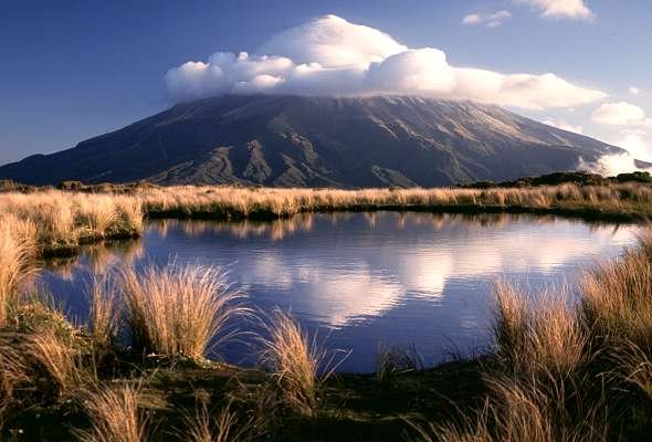